

Plans to develop the banks of the Chicago River into a public walkway were already created at the beginning of the twentieth century, but they only started to materialize almost one hundred years later.
1909 Chicago Plan
Already in 1909, when Daniel Burnham revealed his Chicago plan, he called for the individual owners of lakeshore and riverside properties to create a recreational corridor.
This urban vision has been achieved for the most part at the Chicago Lakefront, where patches of parkland have been connected into one long stretch of public space.
The development of public space along the riverfront however turned out to be a more complicated task. Wile most of the lakefront properties were owned by the city, the properties along the riverfront are almost exclusively in private hands. Hence most of the Chicago riverfront was inaccessible to the public.
Chicago River Corridor Development Plan
The idea of creating a long, uninterrupted public promenade along the Chicago River was relaunched in 1999 by mayor Richard M Daley, who implemented the Chicago River Corridor Development Plan, which required developers along the river to create setbacks allowing the creation of public walkways.
Other parts along the river would be developed by the city. The ambitious plan should ultimately result in almost 28 miles (45km) of waterfront promenades.
Some first steps were made at the beginning of the twenty-first century with the reconstruction of Wacker Drive and the construction of the river esplanade, a waterfront promenade located along the north bank of the Chicago River between Michigan Avenue and the North Lakeshore Drive bridge.
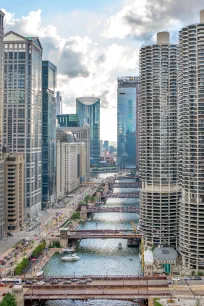
The Riverwalk
In 2002 The Chicago Park District completed a Chicago River Master plan that laid out strategies for improving open space on the river and in 2007 the Chicago Riverwalk Development Committee was formed to work with the city in developing the walkway, now known as Riverwalk. In 2009, architectural firm Skidmore Owings & Merrill created a framework plan that outlined guidelines for the construction of a continuous walkway on both riverbanks along a 1.3-mile-long (2 km) stretch along the Chicago river between Lake Street and Michigan Lake. The plan focused on improving access to the riverfront and the return of plants along the river.
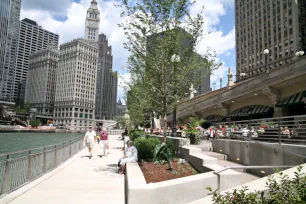
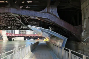
By that time a walkway along the south bank of the river had already opened and by the summer of 2009 stretched from State Street to Lake Michigan. This section, which had an estimated cost of 22 million dollar, included the creation of several underpasses. Before, the paths abruptly ended at junctures and whenever a visitor walked along the river he/she had to climb up, and cross the street to reach the next section. Reflective stainless steel canopies protect the underpasses from anything that may be falling from the bridges above.
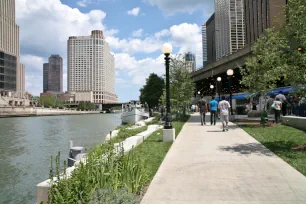
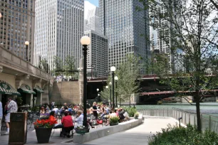
After the opening of the 0.69 mile (1.1 km) long stretch, the Riverwalk started to attract droves of tourists and Chicagoans, who enjoy the urban car-free walk along the river. A number of cafés and eateries opened along the river and there are several attractions such as boat cruises and art displays. The walkway also passes the Bridgehouse & Chicago River Museum, located at the southwest tower of the Michigan Avenue bridge. And you can rent bikes or take a water taxi from the Riverwalk.
Finally, in 2016, another section between West Lake Street and State Street opened, creating a pedestrian corridor stretching over a distance of 1.25 miles (2 km.) from West Lake Street all the way to Michigan Lake. This expansion also led to a doubling of vendors on the Riverwalk, solidifying the project’s success. And the Riverwalk continues to expand thanks to a mandate from the city for new properties along the river to leave space for a public walkway, which resulted in a new stretch along the base of 150 North Riverside and River Point, two spectacular new highrises on Chicago’s riverfront.
Vietnam Veterans Memorial Plaza
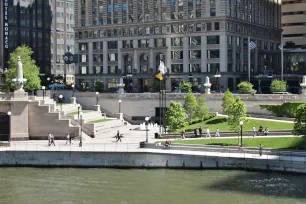
The Riverwalk is at its widest between State and Wabash Street, where you’ll find the Vietnam Veterans Memorial Plaza, also known as Wabash Memorial Plaza.
The plaza, consisting of a terraced lawn, ramps and a memorial, was designed in 2009 by Ross Barney architects. The centerpiece of the plaza is the Vietnam Veterans Memorial, built in 2005. The memorial features a waterfall and a central pool. Along the side of the pool is a timeline with significant events that took place during the Vietnam War. The names of more than 2,900 Illinois men who died in the Vietnam War are engraved in a wall.